1/5


Floods Near Me NSW
1K+Downloads
29.5MBSize
2.2.2(27-03-2022)Latest version
DetailsReviewsVersionsInfo
1/5

Description of Floods Near Me NSW
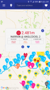
This flood warning app presents the latest flood related information in NSW and provides the user with tailored warnings.
Use the map to view:
+ User’s Current Location or Dropped Pin
+ Road Closed and Water Over Road locations
+ Observed river gauge heights (with interactive graphs)
+ Compare, rename or make Favourite gauges
+ Flooded River Sections (based on Minor, Moderate and Major flood levels)
+ Flood Watch and Flood Warning information
+ Evacuation Warning, Evacuation Order and Evacuation All-Clear areas
+ User generated content (via login)
+ Provide valuable flood photographs to NSW agencies via photo uploads
Disclaimer: This is a beta version of the app – please report any bugs to data-request@mhl.nsw.gov.au.
Floods Near Me NSW - APK Information
APK Version: 2.2.2Package: com.floodsnearmeName: Floods Near Me NSWSize: 29.5 MBDownloads: 4Version : 2.2.2Release Date: 2022-06-06 12:41:06Min Screen: SMALLSupported CPU: x86, x86-64, armeabi, armeabi-v7a, arm64-v8a, mips, mips64
Package ID: com.floodsnearmeSHA1 Signature: 1D:15:33:7D:B4:3B:F5:AF:43:BE:EB:A0:7D:5B:3B:03:C8:6A:2F:F8Developer (CN): MHLOrganization (O): NSW Public WorksLocal (L): ManlyCountry (C): AUState/City (ST): NSWPackage ID: com.floodsnearmeSHA1 Signature: 1D:15:33:7D:B4:3B:F5:AF:43:BE:EB:A0:7D:5B:3B:03:C8:6A:2F:F8Developer (CN): MHLOrganization (O): NSW Public WorksLocal (L): ManlyCountry (C): AUState/City (ST): NSW
Latest Version of Floods Near Me NSW
2.2.2
27/3/20224 downloads29.5 MB Size
Other versions
2.0.0
20/6/20204 downloads11 MB Size


